
ShekouDaily | July 2, 2019
UPDATE: The SZMB cancelled it’s White Typhoon Warning at 1pm July 3rd. The Yellow Rainstorm and Lightning warnings are still in effect.
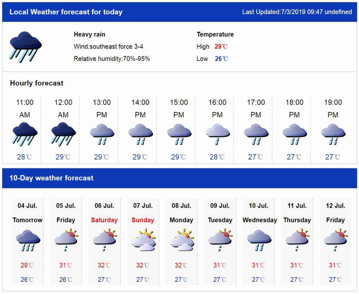
SZMB Weather Forecast (as of 11am, July 3rd)
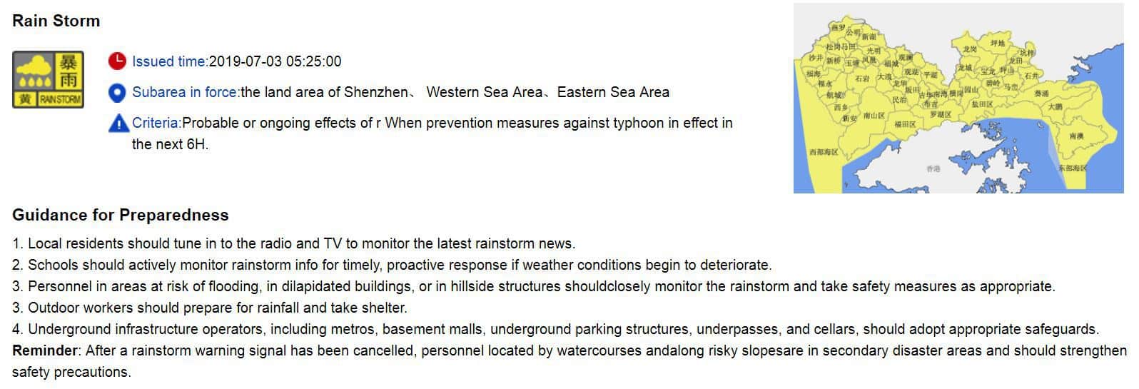
UPDATE: At 5:25 am., July 3rd, the SZMB issued a citywide Yellow Rainstorm Warning.
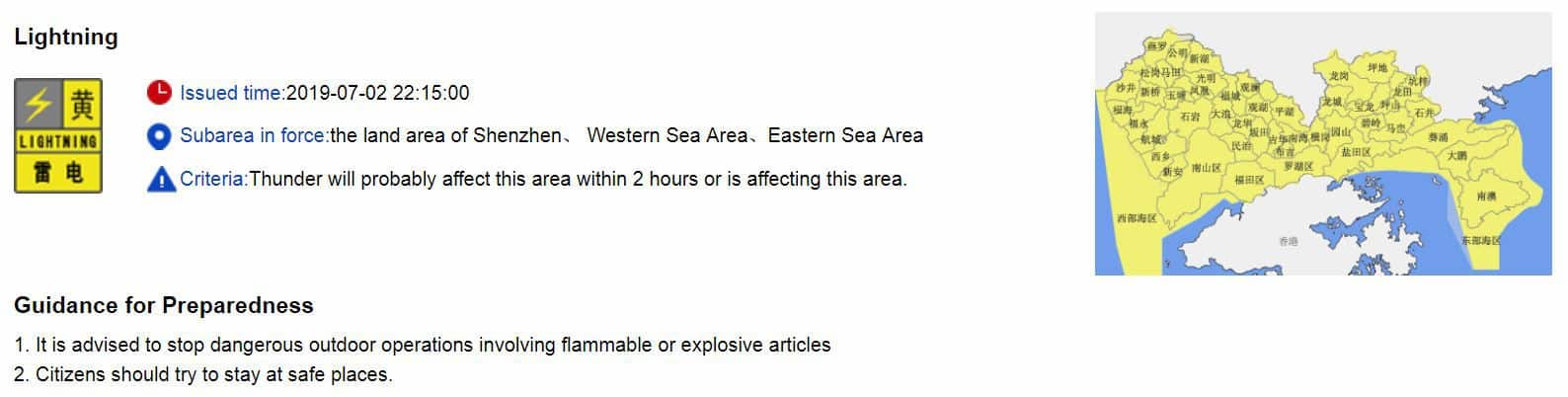
UPDATE: At 10:15pm, the SZMB issued a citywide Yellow Lightning Warning.
UPDATE: At 5pm, the HKO issued it’s Standby Signal, No. 1, is in force. This means that a tropical cyclone now centred within about 800 kilometres of Hong Kong may affect us.
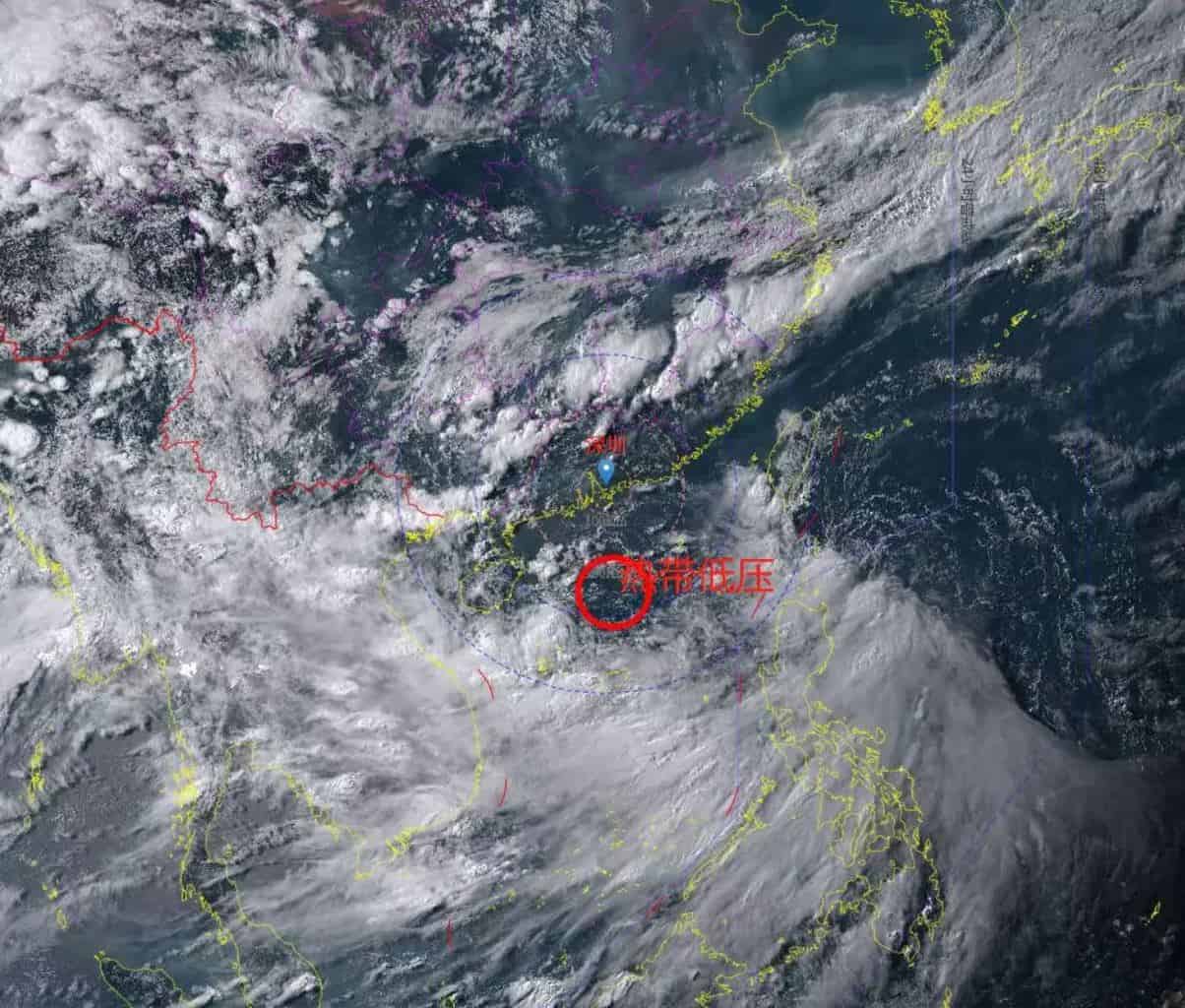
At 5 p.m., Tropical Depression over the northern part of the South China Sea was estimated to be about 450 kilometres south-southwest of Hong Kong (near 18.8 degrees north 112.0 degrees east) and is forecast to move west or west-northwest at about 18 kilometres per hour towards Hainan Island.
According to the present forecast track, the tropical depression will maintain a distance of over 400 kilometres from Hong Kong today. The outer rainbands associated with the tropical depression are bringing heavy showers and squally thunderstorms to the coast of Guangdong.
Unless the tropical depression intensifies significantly or takes a more northerly track, the chance of local winds strengthening significantly today is low. The need to issue the Strong Wind Signal, No. 3 today is not high.
HKO’s Precautionary Announcements with No. 1 Signal
- Precautions should be taken now. Drains should be cleared of obstructions, and windows and doors should be checked.
- People in areas of exposed to high winds or in low-lying areas should take precautions against strong winds and flooding now.
- Those who have duties during a tropical cyclone should now remain on call.
- People planning to visit Guangdong, Macau, outlying islands or remote parts of Hong Kong should note that changes in weather may affect your trips.
- There may be swells, you are advised to stay away from the shoreline and not to engage in water sports.
- Fishing vessels and low power vessels in open sea should seek shelter as soon as possible and be secured properly with moorings.
- Construction and property management practitioners should make sure that overhanging facilities and temporary structures outdoors are securely fastened, and should take precautionary measures.
- Listen to radio, watch TV or browse the Hong Kong Observatory’s website and mobile app for the latest information on the tropical cyclone.
UPDATE: The SZMB reports that the tropical depression is gradually moving west to the north at a speed of about 10-15 km per hour, although it may get larger in the coming days.
Precautionary Tips:
This will be the first tropical system to have a wind and rain impact on the city this year. Please be prepared.
Please prepare your balcony items for strong rainfall accompanied by heavy winds, and stay away factory sheds, temporary structures, outdoor billboards, trees and other objects that are easy to collapse. Take precautions when engaging in outdoor coastal activities.
As the there will be extended periods of rainfall, rain is expected to accumulate and may cause flooding. Stay away from rivers, low-lying areas and other dangerous areas during the rain.
The path and intensity of the typhoon in the South China Sea are complex and variable. The weather station will closely monitor the storm so please pay attention to the latest forecast.
UPDATE: The HKO cancelled their Thunderstorm Warning issued for this morning at 11:20am. The SZMB’s Typhoon Warning is still in effect.
At 8:45pm last night, the Shenzhen Meteorological Bureau (SZMB) issued their first Typhoon Warning Signal of the year.
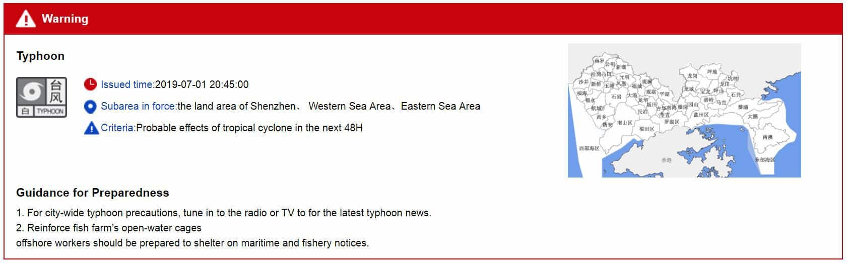
The city-wide White Typhoon Warning Signal indicates that we may experience a typhoon within the next 48 hours.
At 10am this morning, the Hong Kong Observatory (HKO) issued a Special Weather Tip related to the approaching storm:
The area of low pressure over the northern part of the South China Sea is intensifying gradually. A tropical depression appears to be forming. According to the present forecast, it will move west-northwest in the general direction of Hainan Island, maintaining a distance from Hong Kong. The heavy showers and squally thunderstorms associated with this area of low pressure will affect the coast of Guangdong in the next couple of days. Members of the public should be on the alert.
At 10:23am, the HKO issued their Thunderstorm Warning. It will be valid until 12:30 p.m. today, unless extended.
Isolated squally thunderstorms are expected to occur over Hong Kong. Members of the public are advised to take the following precautions when thunderstorms occur:
1. Stay indoors. Seek shelter in buildings if you are engaging in outdoor activities.
2. Do not stand on high grounds. Keep away from highly conductive objects, trees or masts.
We’ll continue to update this page as more information becomes available