
ShekouDaily | October 17, 2016
Many events for this weekend have been rescheduled.Click here for an up-to-date list.
This page is being updated often with information from various weather sources.
UPDATE: 11am October 24th: Many trains into and out of Shenzhen seem to be back to normal; however, not all. Once we’ve confirmed they are, we’ll make the final update to this post.
——–
As of 11am Saturday October 22nd, ticket sales has re-opened for about half the routes out of the Shenzhen Railway stations.
———
Shenzhen Bay Border Crossing re-opened at 9:15 pm October 21.
HKO: All signals were cancelled at 10:10 p.m.
At 10 p.m., Tropical Storm Haima was centred about 280 kilometres north-northeast of Hong Kong (near 24.7 degrees north 115.0 degrees east) and is forecast to move north or north-northeast at about 28 kilometres per hour into inland and continue to weaken.
Occasional strong winds still affect offshore areas and high ground at first. There are also swells. Members of the public should stay away from the shoreline, and not to engage in water sports.
———
According to their real-time flight information tracker, most flights into and out of Hong Kong International Airport resuming as usual.
——–
At 6:18pm, the Shekou Ferry Terminal announced that ferry service will resume Saturday starting from the following times per route:
– Zhuhai – 9:45am
– Hong Kong Airport – 12:15pm
– Macau – 1:00pm
– Central – 12:00pm
For links to the various ferry schedules, click here.
———
The Shenzhen Customs Office announced at 5:21pm October 21st that Shenzhen Bay Border Crossing is temporarily closed. We’ll update this post when we hear it has been re-opened.
———
The Strong Wind Signal, No. 3 is in force. This means that winds with mean speeds of 41 to 62 kilometres per hour are expected. At 6 p.m., Severe Tropical Storm Haima was estimated to be about 180 kilometres north-northeast of Hong Kong (near 23.8 degrees north 114.9 degrees east) and is forecast to move north at about 25 kilometres per hour into inland Guangdong and weaken gradually.
Although local winds are subsiding, occasional gales are still affecting offshore waters and high grounds at first. Seas are rough and there are swells. Members of the public should stay away from the shoreline, and not to engage in water sports.
With Haima continuing to weaken and move away from Hong Kong, local winds will subside further overnight. When the threat posed by Haima to Hong Kong diminishes, the Observatory will cancel all tropical cyclone warning signals overnight.
——-
At 5:20pm October 21, the HKO replaced the No. 8 Southwest Gale or Storm Signal with the No. 3 Strong Wind Signal
——-
At 3:45pm October 21, the HKO announced that… With Haima gradually moving away from Hong Kong, local winds are weakening progressively. The Observatory will consider issuing the Strong Wind Signal No. 3 to replace the No. 8 signal between 5 p.m. and 7 p.m.
——-
At 2:45 October 21, the HKO accounced that… According to the present forecast track, Haima will begin to move away from Hong Kong gradually. Local winds will subside progressively later today. The Observatory will consider issuing the Strong Wind Signal No. 3 to replace the No. 8 signal around dusk.
——–
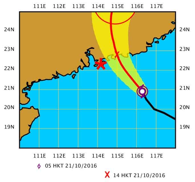
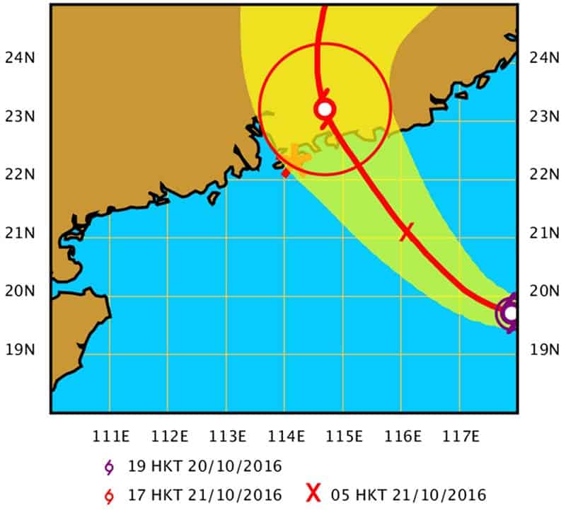
At 2pm October 21, the HKO announced that… Typhoon Haima was centred about 110 kilometres east-northeast of Hong Kong (near 22.8 degrees north 115.1 degrees east) and is forecast to move north-northwest at about 25 kilometres per hour into inland Guangdong.
Haima has made landfall in the vicinity of Shanwei. Winds over Hong Kong are turning to the southwest gradually. Places which have been sheltered before will become more exposed to high winds. Gales will affect the territory for some time. The No. 8 Gale or Storm Signal is expected to remain in force most of the time in the afternoon.
At 1pm, the Meteorological Bureau of Shenzhen downgraded the citywide Typhoon Alert from Orange to Yellow.
————–
At 12:45 October 21st, the HKO announced that… Haima is making landfall in the vicinity of Shanwei. Winds over Hong Kong will turn to the southwest gradually this afternoon. Places which have been sheltered before will become more exposed to high winds. As the western part of Haima’s eye wall is rather close to Hong Kong, gales will affect the territory for some time. The No. 8 Gale or Storm Signal is expected to remain in force most of the time in the afternoon.
The rainbands of Haima are bringing squalls and heavy rain to the territory. Seas are rough and there are swells. Members of the public should stay on high alert, stay away from the shoreline, and not to engage in water sports.
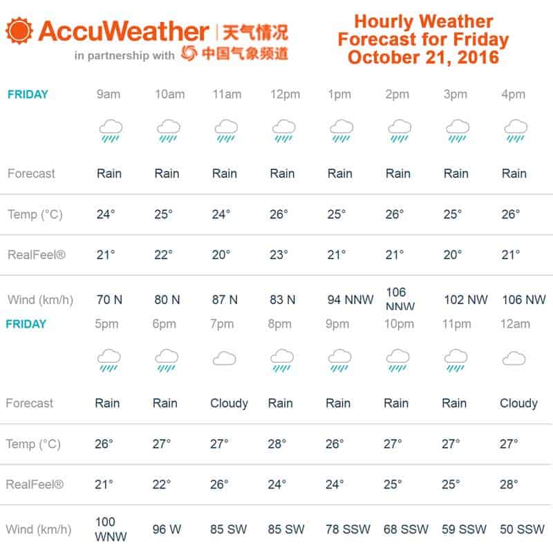
Accuweather’s hourly weather report has downgraded wind speeds from 106 km/h for 2 and 4pm when checked at 9:45am to just 54 km/h for 7pm when we checked again at 12:45pm.
———-
At noon the HKO announced that… Typhoon Haima was centred about 130 kilometres east-northeast of Hong Kong (near 22.6 degrees north 115.4 degrees east) and is forecast to move northwest or north-northwest at about 25 kilometres per hour across the coast of eastern Guangdong and move inland. Haima will make landfall about 100 km to the east of Hong Kong shortly. Winds over Hong Kong will turn to the southwest gradually this afternoon. Places which have been sheltered before will become more exposed to high winds. As the western part of Haima’s eye wall is rather close to Hong Kong, gales will affect the territory for some time. The No. 8 Gale or Storm Signal is expected to remain in force most of the time in the afternoon. The rainbands of Haima will continue to bring squalls and heavy rain to the territory this afternoon. Seas are rough and there are swells. Members of the public should stay on high alert, stay away from the shoreline, and not to engage in water sports.
———–
At 10:50am October 21, the Meteorological Bureau of Shenzhen downgraded the Sea Wave Alert from Orange to Yellow and the Storm Surge Alert from Yellow to Blue.
———-
At 11 am October 21, the HKO announced that: Widespread heavy rain may affect Hong Kong in a couple of hours. Members of the public should be on the alert.
———-
October 21 9:30am. Accuweather is forecasting the strongest winds of 106 km/h for this area at about 2pm and 4pm today.
Here is the hourly weather forecast provided by Accuweather as of Friday October 21st at 9:30am:
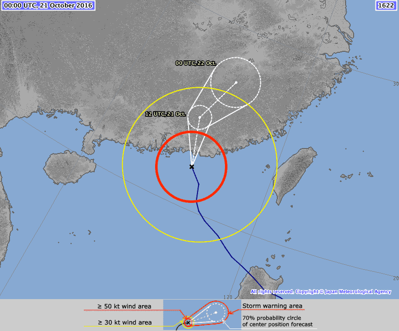
Here is the latest forecasted trajectory by the Japan Meteorological Agency at 9am JST Oct 21:
UPDATE: The Hong Kong Observatory issued the No. 8 Gale or Storm Signal at 6:15 am October 21st. Haima will be closest to Hong Kong around noon, skirting about 100 km to the east of the territory. The No. 8 Gale or Storm Signal is expected to remain in force most of the time during the day.
Here are the Precautionary Actions Recommended if The Number 8 Gale Or Storm Signal Is Issued:
Complete all precautions now before gales commence. Lock all windows and doors. Fit bars into positions and insert reinforced shutters and gates if available. Adhesive tape fixed to large window panes in exposed positions will reduce damage by broken glass. Do not stand near windows on the exposed side of your home. Move all furniture and valuables away from these areas. Make sure you have a safe place to shelter, should windows be broken. Now is the time to decide which rooms you will use to shelter if the windows on the exposed side of your home become broken. Owners of neon signs should arrange for the electricity supply to their signs to be switched off. Park your car where it is least likely to be damaged. Avoid staying in the street. Return home as soon as possible if conditions so permit.
———–
At 5 am October 21, the HKO announced that Typhoon Haima was estimated to be about 270 km southeast of Hong Kong with maximum sustained wind near center of 145 km/hand. It is forecast to move northwest or north-northwest at about 25 kilometres per hour towards the vicinity east of the Pearl River Estuary.
At 4:10am October 21, The Hong Kong Observatory announced that the Tropical Cyclone Warning Signal Number 8 is expected to be issued at or before 6:30 a.m. today.
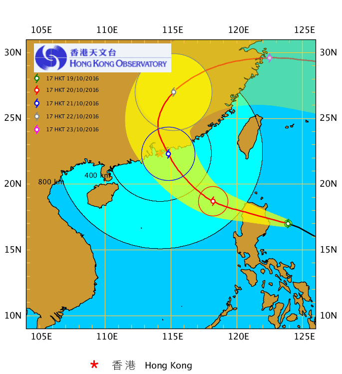
Forecast Trajectory of Typhoon Haima by the Hong Kong Observatory as of 5am October 21:
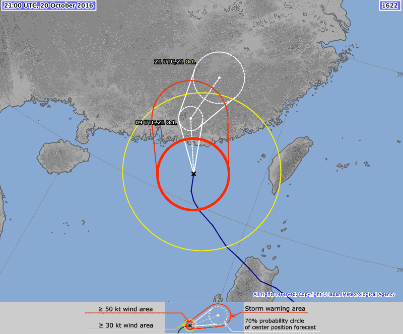
Here is the latest forecasted trajectory by the Japan Meteorological Agency at 6am JST Oct 21:
At 00:20 am October 21st the Meteorological Bureau of Shenzhen upgraded the city-wide Typhoon Alert from Yellow to Orange.
———-
At 3 am October 21, the HKO announced Severe Typhoon Haima has weakened into a typhoon while about 310 kilometres southeast of Hong Kong with maximum sustained winds of 145 k/h. The Strong Wind Signal, No. 3 is still in force.
———-
By the early morning hours of October 21st most flights on Hong Kong airport’s Flight Schedule displayed a status of “Cancelled.”
———-
HKO announced at 11:45pm October 20th that Haima is rather intact and is moving closer to Hong Kong steadily, posing substantial threat to the territory. According the present forecast track, the Observatory will consider issuing No. 8 Gale or Storm Signal in the morning on Friday.
———-
The HKO issued the Strong Wind Signal, No. 3 at 8:40 p.m. October 20th. Here is a description of the actions they suggest:
Secure all loose objects, particularly those on balconies and rooftops. Flower pots and other objects likely to be blown away should be taken indoors. Secure hoardings, scaffoldings and temporary structures. Drains should be cleared to avoid blockage and overflows. Stay away from the shoreline and not to engage in water sports. Fishing vessels should seek shelter without delay. Listen to radio and TV announcements and browse the Observatory website for further information about the tropical cyclone.
————-
Local winds are expected to strengthen significantly tomorrow. Depending on the intensity and movement of Haima and the wind conditions over Hong Kong, the Observatory will consider issuing the No. 8 Gale or Storm Signal tomorrow morning.
————
CCTV reporting that Haima will “wreak havoc and cause great loses” in Guangdong.
Weather Underground is predicting landfall well east of Guangdong province at about 2pm Friday October 21st. The Hong Kong Observatory and Japan Meteorological Agencies have different predictions much closer to us.
————-
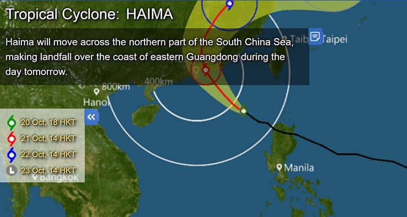
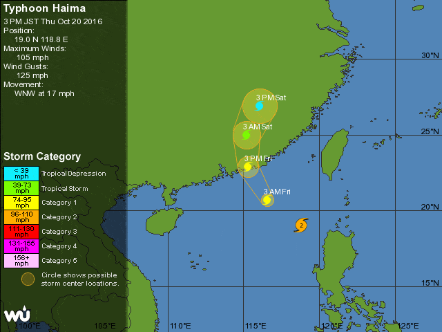
The HKO announced that at 7pm October 20th Severe Typhoon Haima was about 480 km southeast of Hong Kong with maximum sustained wind near center at 155 km/h. Haima will move across the northern part of the South China Sea, making landfall over the coast of eastern Guangdong during the day tomorrow. Maximum sustained wind near the center at 5pm tomorrow October 21st is forecasted at 130 km/h.
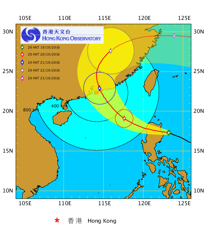
Here is the latest forecasted trajectory of Typhoon Haima by the Hong Kong Observatory as of 7pm October 20:
Here is the latest forecasted trajectory by the Japan Meteorological Agency at 6pm JST Oct 20:
At 6:00pm October 20, the HKO announced that Severe Typhoon Haima is located about 510 km southeast of Hong Kong with current maximum sustained wind near centre of 165 km/h. Haima will move across the northern part of the South China Sea, making landfall over the coast of eastern Guangdong during the day tomorrow.
———–
Watch the HKO’s Central Briefing by Song Man Kuen, Senior Scientific Officer. Broadcasted at 5pm today.
Weather forecast for tonight and tomorrow: Mainly cloudy. Moderate north to northwesterly winds. Winds will strengthen gradually with a few showers overnight. Frequent squalls and heavy rain tomorrow. Seas will be rough with swells. Winds will reach gale force offshore, becoming west to southwesterlies tomorrow afternoon. Temperatures will range between 24 and 27 degrees tomorrow. Outlook: Rain will ease off later on Saturday. Weather will improve early next week.
Here is the latest HKO forecasted trajectory:
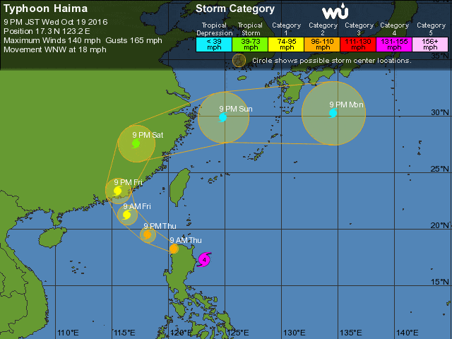
Here is the Weather Underground’s forecasted trajectory. We hope they’re right!
At 5:22pm October 20th, the Meteorological Bureau of Shenzhen announced that all city schools will be closed tomorrow. Between 6-8pm they are expecting to upgrade the Typhoon Blue Alert to Yellow.
At 4:13 pm October 20th, the Meteorological Bureau of Shenzhen announced a Shenzhen Wave RED ALARM for the Shenzhen Bay area. Waves are expected to reach 2.5-4 meters in height. The alarm is in effect until 4pm tomorrow.
———-
For those traveling to Shenzhen from the Hong Kong Airport, China Travel Tours Transportation said their last bus will leave at 10pm to Shenzhen Bay Port and Huanggang. They are located at Counter C11, Coach Station, Terminal 2 in the Hong Kong Airport. They can be reached at +852 3559 1474. We called all other coach services listed on the airport web site and the remaining said they will either stop service soon or did not answer the phone.
Shenzhen Daily reported today at 11:23am that “the Shenzhen North Railway Station has suspended sales of tickets dated tomorrow and Saturday for trains running on the Xiamen-Shenzhen Railway.” We’ve checked the train ticket purchasing system and it looks like 90% of all trains leaving Shenzhen from both railway stations are now cancelled for tomorrow. Many arriving to Shenzhen have also been cancelled.
————
We’ve been following the Hong Kong Airport Flight Information and there are still flights scheduled to depart as late as 10:45 pm tonight. We’ll update this post if anything changes.
Shenzhen Airport is showing many delays due to weather but we haven’t seen any cancellations yet.
————
Ferry cancellations beginning Thursday October 20th! Below is the revised schedule. Check back for updates.
Shekou to Zhuhai – > No ferries after 4pm
Zhuhai to Shekou – > No ferries after 3pm
Shekou to HK Airport – > No ferries after 4:30pm
HK Airport to Shekou – > No ferries after 5:30pm
Shekou to Macau – > No ferries after 3:30pm
Macau to Shekou – > No ferries after 5pm
Ferry schedule updates can also be found at the schedules posted here.
——–
Shenzhen Government has issued the Blue Alarm ahead of the arrival of Typhoon Haima which is expected to bring strong winds and heavy rains to Shenzhen. More on this shortly.
———
8:45 am October 20: The Standby Signal, No. 1 is in force and the Observatory will consider issuing the Strong Wind Signal, No.3 later today. Here is a summary of the latest announcement:
Haima will move across the northern part of the South China Sea today. It is now centred within about 800 kilometres of Hong Kong. It will still be at a distance from Hong Kong during the day. According to the present forecast track, Haima will edge close to the coast of Guangdong tomorrow and may be rather close to Hong Kong (with maximum sustained winds of 140 km/h). As Haima moves progressively towards the coast of Guangdong, local winds will strengthen gradually overnight and there will also be swells.
Here is the projected track by the HKO as of 8 am Thursday October 20:
The following precautions are recommended with with No. 1 Signal
1. Some precautions against damage should be taken now, gutters and drains should be cleared of obstructions. Hinges, bolts, locks and shutters of windows and doors should be checked.
2. People living in wooden huts and in low-lying areas should take necessary precautions against strong winds and flooding.
3. Those who have definite duties during a tropical cyclone should now remain on call or contact their control centres from time to time.
4. If you are planning to visit Guangdong, Macau, any of the off-shore islands or remote parts of Hong Kong, you are reminded that changes in weather may affect your plans.
5. Since there will be swells, you are advised to stay away from the shoreline and not to engage in water sports.
6. Engineers, architects and contractors should make sure that scaffoldings, hoardings and other temporary structures are secured.
7. All small vessels including low power vessels and fishing vessels in open sea should seek shelter as soon as possible. Please take any precautions necessary for small vessels and secure them properly with moorings.
8. Owners of shop signs, advertisements and TV aerials which overhang public thoroughfares or which are situated on tops of buildings should make sure that the fastenings and framework of these structures are secured.
9. Listen to radio, watch TV or browse the Hong Kong Observatory’s web site for information on the tropical cyclone.
————
00:00 October 20. Haima will move across the northern part of Luzon and enter the South China Sea on Thursday morning. The HKO will issue Standby Signal, No. 1 by then. According to the present forecast track, Haima will edge closer to the coast of Guangdong on Friday, and may skirt within 100 kilometers of Hong Kong, posing a threat to the territory.
————
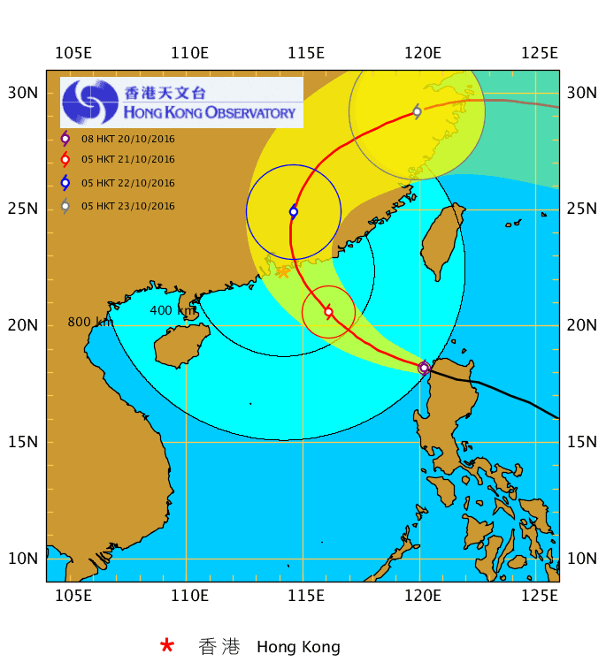
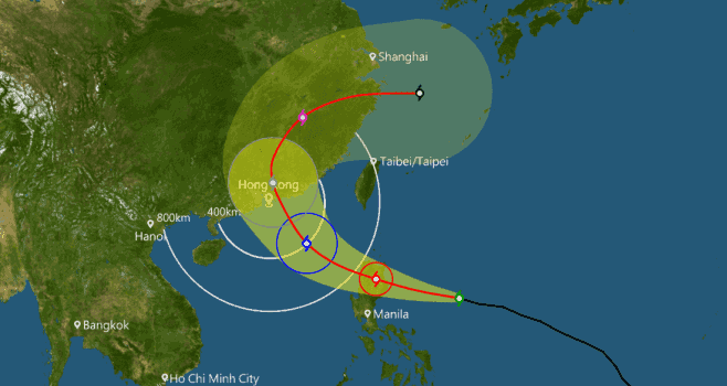
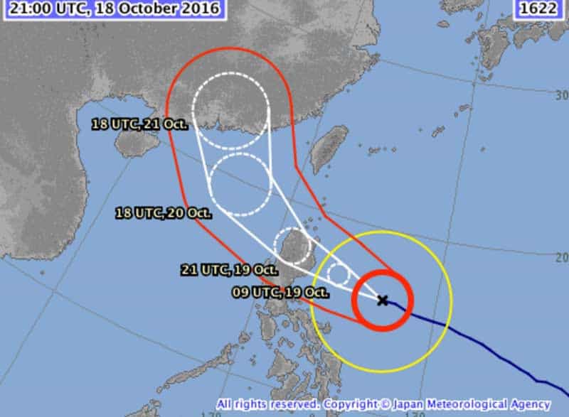
Below are the latest forecasts of Haima’s trajectory from the Japan Meteorological Agency (Oct 20 00:00 JST), the Hong Kong Observatory (Oct 19 8pm) and Weather Underground (Oct 19 9pm JST). The JMA and HKO both forecast a 70% probability of Haima making landfall very near on Friday with maximum sustained wind speeds estimated at 130 km/h by the HKO.
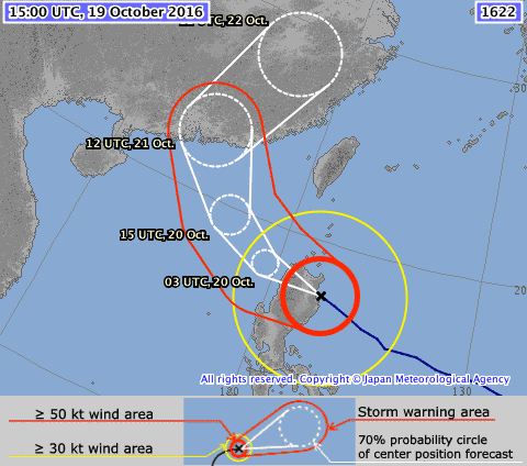
Super Typhoon Haima Projected Trajectory – Japan Meteorological Agency (October 20 00:00 JST)
Super Typhoon Haima Projected Trajectory – Hong Kong Observatory (October 19 8pm HKT)
Super Typhoon Haima Projected Trajectory- Weather Underground (October 19 9pm JST)
———–
Rainstorm Warning cancelled at 9 pm October 19th. People should stay alert to the danger that may be brought about by river flooding.
———–
Weather forecast for tonight and tomorrow updated at 7pm October 19: Cloudy with squally showers and thunderstorms. Showers will be heavy at first. Showers will ease off overnight. Sunny periods tomorrow. Temperatures will range between 25 and 31 degrees. Moderate east to northeasterly winds, fresh later tomorrow and there will be swells. Outlook: Frequent heavy rain with squalls on Friday. Seas will be rough with swells. Rain will ease off later on Saturday.
Here is the projected trajectory at 5pm October 19
———–
Amber Rainstorm Warning Signal Special Announcement issued by the Hong Kong Observatory at 6:15 p.m. This means that heavy rain has fallen or is expected to fall generally over Hong Kong, exceeding 30 millimetres in an hour, and is likely to continue. There will be flooding in some low-lying and poorly drained areas. People who are likely to be affected should take necessary precautions to reduce their exposure to risk posed by the heavy rain and flooding. Heavy rain may bring about flash floods. People should stay away from watercourses. People who are likely to be affected by flooding should take necessary precautions to avoid losses.
————
Red Rainstorm Warning Signal Special Announcement issued by the Hong Kong Observatory at 5:15 p.m. The Rainstorm Warning Signal is now Red. This means that heavy rain has fallen or is expected to fall generally over Hong Kong, exceeding 50 millimetres in an hour, and is likely to continue. Further heavy rain could cause, if not already caused, serious road flooding and traffic congestion and could disrupt normal school hours. Parents, students, school authorities and school-bus drivers should listen to radio or television announcements on schools. People who have to travel should carefully consider the weather and road conditions and take necessary precautions. Heavy rain will bring flash floods, and flooding is occurring or is expected to occur in watercourses. People should stay away from watercourses. Residents living in close proximity to rivers should stay alert to weather conditions and should consider evacuation if their homes may become flooded.
———-
The Black Rainstorm Warning Signal Special Announcement was issued by the Hong Kong Observatory at 4:00 p.m. This means that heavy rain has fallen or is expected to fall generally over Hong Kong, exceeding 70 millimetres in an hour, and is likely to continue. Because of seriously flooded roads and inclement weather conditions, you are advised to take shelter in a safe place and stay there. Do not attempt to travel until the Black Rainstorm Warning Signal is no longer in force and traffic conditions have improved. Heavy rain will bring flash floods, and flooding is occurring or is expected to occur in watercourses. People should stay away from watercourses. Residents living in close proximity to rivers should stay alert to weather conditions and should consider evacuation if their homes may become flooded.
———–
HKO Weather forecast for this afternoon and tonight updated at 3:45pm October 19: Cloudy with squally showers and thunderstorms. Showers will be heavy at first. Fresh east to southeasterly winds, occasionally strong offshore at first. Seas will be rough with swells. Outlook: Sunny periods tomorrow. Frequent heavy rain with squalls on Friday. Seas will be rough with swells. Rain will ease off later on Saturday.
————
Thunderstorm Warning issued at 10:30 a.m. on October 19th has been extended until 3:30 p.m. today. Isolated squally thunderstorms are expected to occur over Hong Kong. Gusts reaching 70 kilometres per hour or above may affect Hong Kong. The Amber Rainstorm Warning Signal Special Announcement was issued by the Hong Kong Observatory at 1:30 p.m. This means that heavy rain has fallen or is expected to fall generally over Hong Kong, exceeding 30 millimetres in an hour, and is likely to continue. There will be flooding in some low-lying and poorly drained areas. People who are likely to be affected should take necessary precautions to reduce their exposure to risk posed by the heavy rain and flooding. Heavy rain may bring about flash floods. People should stay away from watercourses. People who are likely to be affected by flooding should take necessary precautions to avoid losses.
————
HKO Advisories issued at 11am Oct 19: Widespread heavy rain may affect Hong Kong in a couple of hours. Members of the public should be on the alert. Thunderstorm Warning has been extended until 12:30 p.m. today. Isolated squally thunderstorms are expected to occur over Hong Kong. Gusts exceeding 70 kilometres per hour were recorded at Cheung Chau at around 10:50 a.m. Gusts reaching 70 kilometres per hour or above may continue to affect Hong Kong.
Members of the public are advised to take the following precautions when thunderstorms occur:
1. Stay indoors. Seek shelter in buildings if you are engaging in outdoor activities.
2. Do not stand on high grounds. Keep away from highly conductive objects, trees or masts.
3. Take precautions against violent gusts. Beware of flying debris and falling objects.
4. Drivers using highways and flyovers should reduce speed to be alert to violent gusts.
———-
8:45am October 19: HKO’s Weather forecast for today: Cloudy with squally showers. Showers will ease off gradually later. The maximum temperature will be about 27 degrees. Fresh east to southeasterly winds, occasionally strong offshore at first. Seas will be rough with swells. Outlook: Sunny periods tomorrow. Heavy squally showers and swells on Friday and Saturday. Summary of two HKO statements received in the early morning hours of October 19th: Sarika will dissipate inland today while Haima will move towards the northern part of Luzon today (with 220 km/h maximum sustained winds). It is expected to enter the northern part of South China Sea on Thursday and edge close to the coast of Guangdong on Friday (with estimated 140 km/h winds)
———
The Hong Kong Observatory at 9:20 a.m. on 19 October 2016 issued this Landslip Special Announcement:
* Keep away from steep slopes or retaining walls.
* Motorists should avoid driving in hilly areas or on roads with landslip warning signs.
* Cancel non-essential appointments, stay at home or remain in a safe shelter.
* If you see signs of landslip danger, keep away from the area and report to the Police.
———
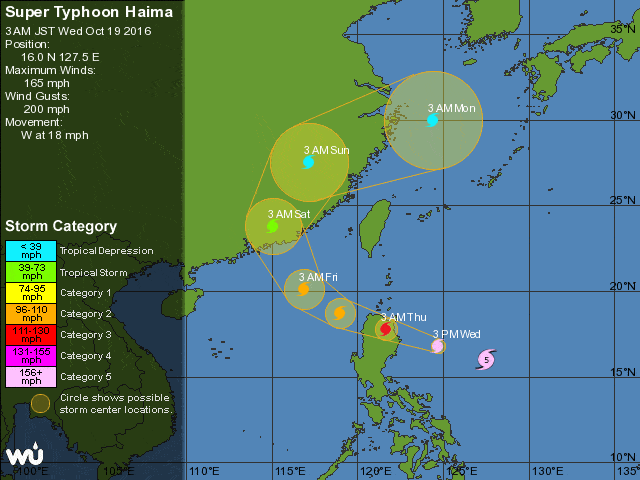
The following images are projected trajectories from Weather Underground, the Hong Kong Observatory and the Japan Meteorological Agency as of October 19th early morning.
Super Typhoon Haima Projected Trajectory- Weather Underground (October 19 3am JST)
Super Typhoon Haima Projected Trajectory- Hong Kong Observatory (October 19 2am HST)
Super Typhoon Haima Projected Trajectory- Japan Meteorological Agency (October 19 9am JST)
—————
The HKO cancelled all signals at 10:10pm October 18th. Occasional strong winds are still expected overnight. Members of the public should stay on the alert. Since seas are rough and there are swells, you are advised to stay away from the shoreline and not to engage in water sports.
—————