
ShekouDaily | August 22, 2019
UPDATE: At 7:20 p.m., the HKO cancelled all their storm warnings.
At 7 p.m., Tropical Depression Bailu was centred about 280 kilometres north of Hong Kong (near 24.8 degrees north 114.7 degrees east) and is forecast to move west-northwest at about 20 kilometres per hour further inland.
Winds in Hong Kong will still be occasionally strong on high ground at first. There will also be swells over the sea. Members of the public should remain on the alert.
This page will no longer be updated.
UPDATE: At 5 p.m., the SZMB cancelled their typhoon warning.
UPDATE: The HKO has cancelled it’s Thunderstorm Warning; however, the Standby Signal No. 1 is still in effect. See below for precautions to take.
This means that a tropical cyclone now centred within about 800 kilometres of Hong Kong may affect us.
At 3 p.m., Tropical Storm Bailu was estimated to be about 310 kilometres north-northeast of Hong Kong (near 24.7 degrees north 115.8 degrees east) and is forecast to move west-northwest at about 25 kilometres per hour crossing southeastern part of China.
UPDATE: The HKO’s Thunderstorm Warning is extended to at least 3 p.m.
UPDATE: HKO issues Thunderstorm Warning at 10:55 a.m.
Thunderstorm Warning was issued at 10:55 a.m. on 25 Aug 2019. It will be valid until 1:00 p.m. today. Occasional squally thunderstorms are expected to occur over Hong Kong. Gusts reaching 70 kilometres per hour or above may continue to affect Hong Kong.
Members of the public are advised to take the following precautions when thunderstorms occur:
1. Stay indoors. Seek shelter in buildings if you are engaging in outdoor activities.
2. Do not stand on high grounds. Keep away from highly conductive objects, trees or masts.
3. Take precautions against violent gusts. Beware of flying debris and falling objects.
4. Drivers using highways and flyovers should reduce speed to be alert to violent gusts.
UPDATE: From the HKO, August 25th, 7:45 a.m.
Bailu has made landfall near Dongshan in Fujian. Bailu will then weaken gradually. The chance of generally strong winds in Hong Kong is relatively low. Unless Bailu takes on a track closer to the Pearl River Estuary, the chance of Strong Wind Signal, No. 3 is not high. The Standby Signal, No. 1 will remain in force for a period of time.
The outer rainbands of Bailu will affect Guangdong, bringing squally showers to the region today.
UPDATE: The HKO Standby Signal No. 1 is in effect. This means that Bailu is within 800 km of Hong Kong.
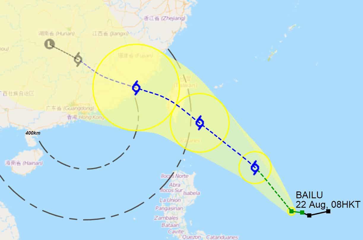
At 3 p.m., Severe Tropical Storm Bailu was estimated to be about 650 kilometres east of Hong Kong (near 22.3 degrees north 120.5 degrees east) and is forecast to move northwest at about 28 kilometres per hour entering the Taiwan Strait.
According to the present forecast track, Bailu will maintain a distance of over 400 kilometres from Hong Kong during the day, and local winds will not generally strengthen. The chance of issuing the Strong Wind Signal, No. 3 during the day is not high.
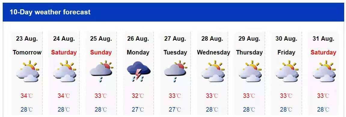
Under the influence of the subsiding air of Bailu, it will be very hot with haze in Hong Kong today. The high temperatures may trigger showers and isolated squally thunderstorms later today.
HKO’s Precautionary Announcements with No. 1 Signal
1. Precautions should be taken. Windows and doors should be checked.
2. Drains should be cleared of leaves and rubbish. People in low-lying areas should take precautions against flooding.
3. Those who have duties during a tropical cyclone should now remain on call.
4. People planning to visit Guangdong, Macau, outlying islands or remote parts of Hong Kong should note that changes in weather may affect your trips.
5. There may be swells. You are advised to stay away from the shoreline and not to engage in water sports.
6. Construction and property management practitioners should make sure that overhanging facilities and temporary structures outdoors are securely fastened, and should take precautionary measures.
7. Listen to radio, watch TV or browse the Hong Kong Observatory’s website and mobile app for the latest information on the tropical cyclone.
UPDATE: HKO announcement, August 24th, 9:05 a.m.
Tropical Cyclone Bailu near the southern part of Taiwan has entered within 800 km of Hong Kong. It is expected to maintain a distance of more than 600 km from Hong Kong this morning (24 August). It will not pose direct threat to Hong Kong for the time being.
We’ll continue to update this page with any updates regarding Bailu’s affects on Shenzhen.
UPDATE: As of 8 a.m., August 24th, Bailu had maximum sustained wind near its center of 105 km/h, classifying it as a “Severe Tropical Storm.”
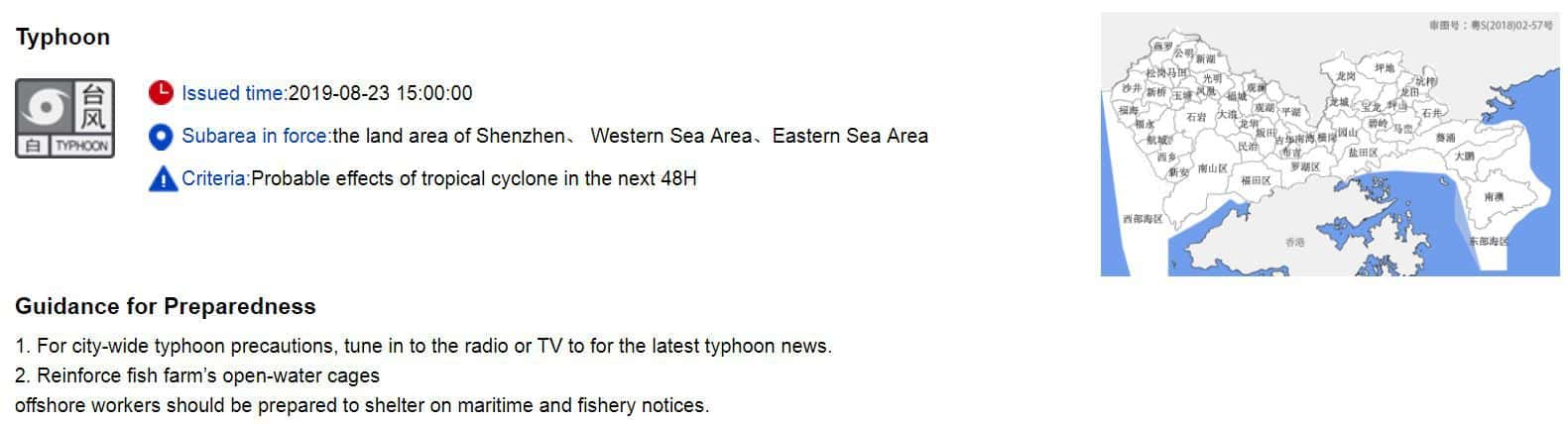
UPDATE: At 3 p.m., August 23rd, the SZMB issued their White Typhoon Warning for the entire city.
ORIGINAL ARTICLE:
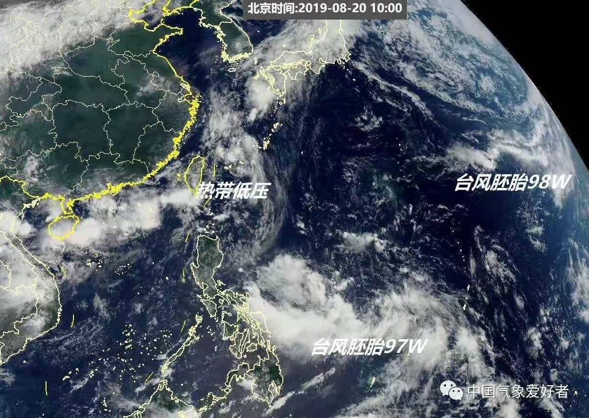
At 2pm yesterday, the Shenzhen Meteorological Bureau reported that Tropical Storm Bailu had formed east of the Philippines, about 2,000 km away from Shenzhen.
It is expected to move northwest and intensify gradually with likely landfall on the coast of Guangdong and or Fujian on the 23rd.
According to the Hong Kong Observatory (HKO), Bailu will move across the western North Pacific in the next couple of days and affect the vicinity of Taiwan during the weekend.
Bailu had sustained winds near its center of 75 km/h as of 8am this morning.
It’s currently classifed as a Tropical Storm; however, it’s expected to become a Sever Tropical Storm by the 24th with wind speeds as high as 110 km/h.
Although the likelihood of landfall in Shenzhen is low, we can expect the weather to deteriorate towards the end of the weekend and into next week.
Sources: