
ShekouDaily | August 25, 2017
All alerts have been cancelled.
We’ll no longer update this post.
UPDATE: By 5:30pm, both the HKO and SZMB have cancelled their Thunderstorm and Rainstorm warning respectively.
———–
UPDATE: At 4:15pm, the HKO extended their Thunderstorm warning until at least 5:30pm
———–
UPDATE: At 11am, the HKO extended their Thunderstorm warning until at least 1pm.
———–
UPDATE: The HKO cancelled it’s Rainstorm Warning at 8:45am; however, it’s Thunderstorm warning is expected to stay in effect until at least 11am.
———–
UPDATE: All Tropical Storm Pakhar warnings were cancelled last night; however, rainstorm warnings were issued by both the the HKO and SZMB this morning Monday August 28th, and are expected to remain in effect for most of the morning.
———–
UPDATE: The HKO cancelled it’s landslide warning at 11:15pm.
———–
UPDATE: All HKO Tropical Cyclone Signals were cancelled at 10:10 p.m.
———–
UPDATE: 8:45pm, the HKO Thunderstorm warning is cancelled. Tropical Storm Pakhar has weakened into a tropical depression. Occasional strong winds are still affecting offshore areas of Hong Kong. Depending on the changes in local winds, the Observatory will consider cancelling all Tropical Cyclone Warning Signals.
———–
UPDATE: Ferry Service to and from Shekou is intermittent for Monday August 28th. Click here for the latest.
———–
UPDATE: At 6pm, The HKO reported that Tropical Storm Pakhar was estimated to be about 380 kilometres west-northwest of Hong Kong and is forecast to move west-northwest at about 28 kilometres per hour further inland and weaken. Occasional strong winds reaching 80 km/h or above may continue to affect Hong Kong. Depending on the changes in local winds, the Observatory will consider cancelling all Tropical Cyclone Warning Signals.
The Standby Signal, No. 1 was issued at 5:40 p.m. The Thunderstorm Warning issued at 11:55 a.m. has been extended until 8:00 p.m. today. A few squally thunderstorms are expected to occur over Hong Kong.
Flight delays are currently being reported. Click here for real-time flight info at HKIA or click here for flight queries from Shenzhen Airport.
The SZMB cancelled all Typhoon warnings at 3:40pm and the Rainstorm warning at 5:45. A landslide warning went into effect at 8:10 this morning and is expected to stay in effect until tomorrow morning at 8:10am.
———–
UPDATE: At 3:10pm, the HKO extended the Thunderstorm warning until 5:30pm today.
———–
UPDATE: By 2:15pm, the HKO cancelled the Amber Rainstorm Warning; however, the Thunderstorm warning is extended until at least 3:30pm today.
———–
UPDATE: At 2 p.m., Tropical Storm Pakhar was estimated to be about 240 km west of Hong Kong with maximum sustained wind near center of 85 km/h. Pakhar will move further inland and weaken gradually. The Strong Wind Signal No.3 is expected to remain in force for some time. The Observatory will consider to issue the Standby Signal No. 1 when strong winds no longer affect Hong Kong. Heavy showers may also cause flooding in low-lying areas. Seas will be rough with swells. Members of the public are advised to stay away from the shoreline and not to engage in water sports.
———–
UPDATE: At 1:40pm, the No. 3 Strong Wind Signal was issued by the HKO to replace the No. 8 Southeast Gale or Storm Signal.
———–
UPDATE: At 12:10pm, the SZMB downgraded the rainstorm warning from Orange to Yellow stating probable or ongoing effects of Pakhar over the next 6 hours.
———–
UPDATE: All ferry service to and from Shekou today has been cancelled for today.
———–
Stay Tuned as we’ll continue to update this post with more information as it becomes available.
————
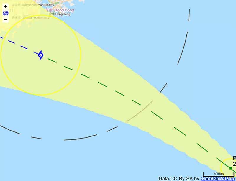
Track the storm in real-time (use your fingers to zoom in and or move around the map below as needed:
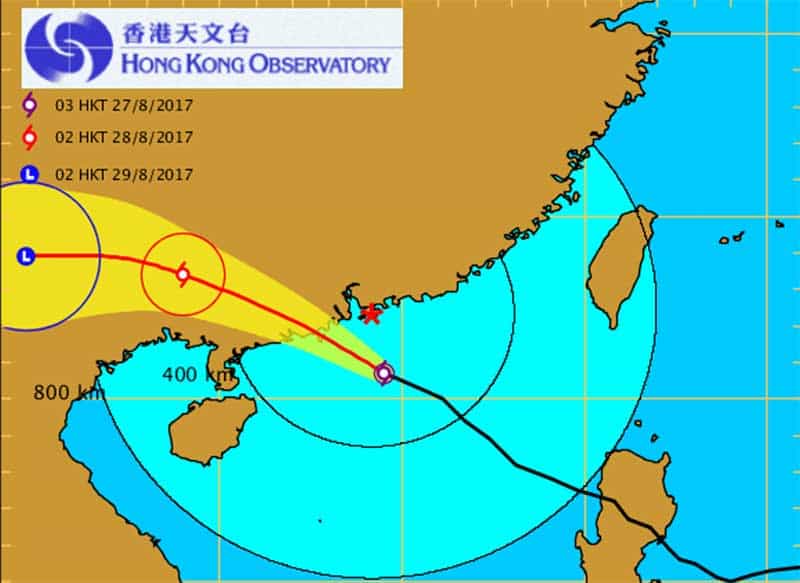
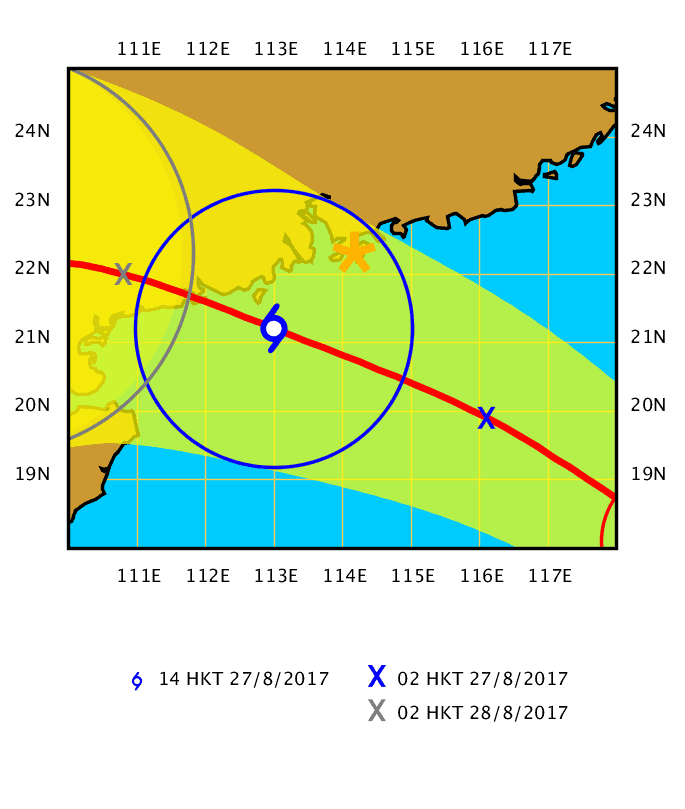
UPDATE: At 11:30pm, the SZMB Upgraded the Typhoon Warning to blue. The HKO announced that at noon, Severe Tropical Storm Pakhar was centred about 170 kilometres west of Hong Kong (near 22.4 degrees north 112.5 degrees east) and is forecast to move northwest at about 25 kilometres per hour into inland Guangdong and weaken gradually. With Pakhar making landfall and departing Hong Kong, local winds are moderating. However, under the influence of Pakhar’s rainbands, high winds are still affecting the southwestern part of Hong Kong. The Observatory will consider issuing the Strong Wind Signal No. 3 before 2 p.m. when local winds weaken further.
———–
UPDATE: HKO’s 9am Announcement – Severe Tropical Storm Pakhar was centred about 90 km west-southwest of Hong Kong Observatory and is forecast to move north-northwest at about 28 kilometres per hour towards the west of the Pearl River Estuary. In the past hour, winds occasionally reached storm force in the southwestern part of Hong Kong and occasionally reached hurricane force on high ground of Lantau Island. Pakhar will land to the west of the Pearl River Estuary in the next couple of hours. The Gale or Storm Signal No. 8 is expected to persist this morning. Rainbands associated with Pakhar are bringing occasional heavy showers and squalls to Hong Kong.
———–
UPDATE: At 8 am, Severe Tropical Storm Pakhar was centred about 100 km southwest of Hong Kong Observatory and is forecast to move northwest at about 28 km/h towards the west of the Pearl River Estuary. Pakhar will land to the west of the Pearl River Estuary in the next few hours. The Gale or Storm Signal No. 8 is expected to persist at least for most of this morning.
———–
UPDATE: At 6:50am, the SZMB upgraded the Typhoon warning to Orange.
————
UPDATE: At 6am, Severe Tropical Storm PAKHAR wsd about 120 km south-southwest of Hong Kong with maximum sustained wind near the center of 110 km/h, according to the HKO. Pakhar will move towards the west of the Pearl River Eastuary.
———–
UPDATE: At 5:10am August 27, the HKO issued the No. 8 Southeast Gale or Storm Signal and the Amber Rainstorm Warning Signal.
“This means that heavy rain has fallen or is expected to fall generally over Hong Kong, exceeding 30 millimetres in an hour, and is likely to continue. There will be flooding in some low-lying and poorly drained areas. People who are likely to be affected should take necessary precautions to reduce their exposure to risk posed by the heavy rain and flooding. Heavy rain may bring about flash floods. People should stay away from watercourses. People who are likely to be affected by flooding should take necessary precautions to avoid losses.
The HKO suggests the following precautionary measures:
1. Complete all precautions in your home. Lock all windows and doors, fit bars into position and insert reinforced shutters and gates if they are available. Adhesive tape fixed to large window-panes in exposed positions will reduce damage by broken glass. Storm water drains should be cleared of leaves and rubbish.
2. Do not stand near windows on the exposed side of your home. Move all furniture and valuables away from these areas. Make sure you have a safe place to shelter, should windows be broken.
————
UPDATE: At 4:05am and 4:20am respectively, the SZMB issued the yellow rainstorm warning and the HKO issued a widespread heavy rain alert.
————
UPDATE: ALL FERRY SERVICES BEFORE 12 NOON SUNDAY, TO AND FROM SHEKOU, ARE CANCELLED.
————
UPDATE: At 3am Sunday August 27th, the HKO announced that the Tropical Cyclone Warning Signal Number 8 is expected to be issued at or before 5:30 a.m. today (27 Aug 2017). Winds locally will strengthen further as PRAKHAR moves closer to the coast of Guangdong today. Severe Tropical Storm PRAKHAR was about 180 km south of Hong Kong with maximum sustained wind near center of 90 km/h.
————
UPDATE: At 8pm, the SZMB upgraded the citywide Typhoon Warning to Yellow and advises people to take the following precautions:
1. Local residents should tune in to the radio or TV for the latest typhoon news.
2. Suspend school/nursery/kindergarten classes. If not ready for school, children may stay at home, and if on the way to/from school, they should be led to the closest shelters. Schools are tasked with ensuring the safety of all children.
3. Suspend operations for sake of employees’ safety (except essential services: emergency rescue, medical, public transport/utilities), and shelter stranded employees.
4. Close exhibitions, markets and coastal parks, and halt outdoor/stadium sporting activities
make appropriate arrangements for the evacuation and shelter the remaining essential or stranded workers.
5. Outdoor workers who are monitoring typhoon/traffic info should avoid trees/billboards/power equipment, never touch fallen power lines, and stay indoors when possible. If necessary, call Civil Affairs Hotline 12349 for help or seek shelter nearby.
6. Promptly take indoor protective measures: strengthen doors and windows, tape windowpanes, and avoid windows from shattering glass. Remove or secure outdoor items to prevent injury.
7. Those in at-risk areas such as seaside, dilapidated buildings, and simple work sheds should seek shelter immediately.
8. Those doing outdoor work in the upper-air or at sea should cease working.
9. All ferries/vessels should stop sailing, take shelter, anchor, and keep close watch. If in distress at sea, call Shenzhen Marine Search and Rescue Center for help, Tel: 12395.
10. Consult airports, seaports, bus terminals and border checkpoints before going there.
————
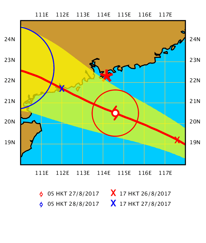
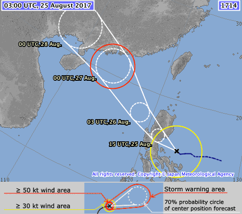
UPDATE: At 11am August 26th, the HKO reported that PAKHAR was about 720 km southeast of Hong Kong with maximum sustained winds at center of 65 km/h. Pakhar will cross the northern part of the south China Sea and intensify gradually. The image below shows the projected trajectory with the blue mark indicating the possible storm position tomorrow.
UPDATE: At 9:45am, The HKO issued the Standby Signal, No. 1 as PAKHAR is now centred within about 800 kilometres of Hong Kong. At 10am, Tropical Storm PAKHAR was estimated to be about 750 kilometres southeast of Hong Kong and is forecast to move northwest at about 30 km/h and intensify gradually. Local winds are expected to strengthen gradually tonight and tomorrow. The HKO will consider issuing the Strong Wind Signal No. 3 around this evening.
“According to the present track, Pakhar will be closest to Hong Kong during the day tomorrow (Sunday) and skirt within about 200 kilometres of the territory. Local weather will deteriorate significantly with squally heavy showers tomorrow. There may be flooding in low-lying areas. Seas will be rough with swells.”
The following precautions are recommended with the Standby Signal No. 1:
1. Protect your home or property. Make sure now that all loose objects are secure. Porch furniture, flower pots and other objects likely to be blown away should be taken indoors. Check again and make sure all windows and doors can be securely locked.
2. Storm water drains should be cleared of leaves and rubbish, this applies particularly to dwellers in low-lying areas.
3. Engineers, architects and contractors should make sure that scaffoldings, hoardings and other temporary structures are secured.
4. All small vessels including low power vessels and fishing vessels in open sea should seek shelter as soon as possible. Please take any precautions necessary for small vessels and secure them properly with moorings.
5. If you are planning to visit Guangdong, Macau, any of the off-shore islands or remote parts of Hong Kong, you are reminded that changes in weather may affect your plans.
6. Those who have definite duties during a tropical cyclone should now remain on call or contact their control centres from time to time.
————-
UPDATE: At 9am Saturday August 26, the Shenzhen Meteorological Bureau announced the Blue Typhoon Warning is in effect for all land areas of Shenzhen as well as the Western and Eastern Sea areas. This signals “Probable or ongoing effects of tropical cyclone or strong breeze in the next 24H.”
They have advised residents to take the following protective measures: Secure windows, doors, hoarding sheets, scaffoldings and temporary structures, and remove/secure outdoor items. Those in seaside locations and in at-risk buildings should be prepared for evacuation. Those working in outdoor, aerial, harbor, and offshore sites should be prepared against strong winds, ensure safety and suspend operations if needed. Fishing vessels/aqua-farmers should land at once according to the notice of the fishery administration sailors/offshore workers should enter anchorage or typhoon shelters on maritime authority’s notice.
As of 9am, the HKO hasn’t yet issued any storm warning. Their forecasted trajectory, as of 5am, tracks PAKHAR taking a more southern route than HATO had.
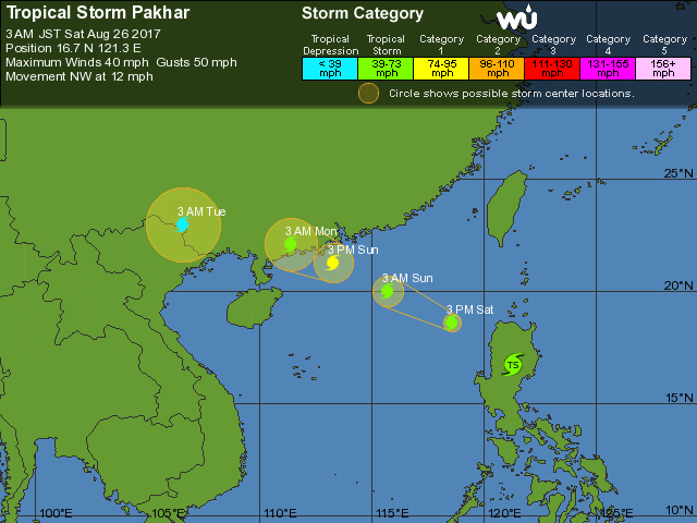
The weather underground updated their projected trajectory this morning around 2am; still south of Hong Kong.
————-
UPDATE: The HKO issued the following announcement at 5:30pm…
“Tropical Storm Pakhar is expected to move across Luzon and enter the South China Sea tomorrow (Saturday). The Observatory will consider issuing the Standby Signal No.1 during the day tomorrow.
Owing to the terrain of Luzon, there is still uncertainty in the future track and intensity of Pakhar after crossing Luzon. It will move in a general northwest direction towards western Guangdong but will probably be further away from Hong Kong than Hato. Local winds are expected to strengthen with occasional heavy squally showers on Sunday. “
————-
At 3pm Friday August 25th, the Shenzhen Meteorological Bureau issued its lowest Typhoon warning for approaching Tropical Storm PAKHAR, advising “Probably effects of tropical cyclone in the next 48H.”
At 2pm Friday, the HKO forecasted that Tropical Storm PAKHAR may reach Severe Tropical Storm classificiation by 2pm Sunday August 27th, with maximum sustained winds at its center of 105 km/h; at which point PAKHAR is estimated to be at 21.2 N, 113.0 E; which is about 100 miles southwest of Shekou.
Based on current information, we may be feeling some effects of PAKHAR about the time of the Mayweather vs McGregor Fight on Sunday; however, according to the HKO’s Tropical Cyclone Track Probability Forecast (Beta), there is only between a 30-40% probability that PAKHAR will pass over Hong Kong in the coming days.
The Japan Meteorological Agency is projecting a similar trajectory to the HKO, with a 70% probability.
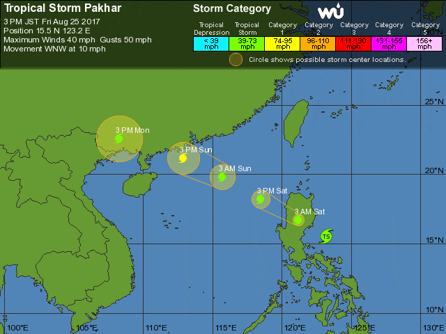
As usual, the Weather Underground is the odd man out forecasting the approaching storm will blow by quite a bit more south compared to the aforementioned projections… as is the real-time typhoon tracker embedded below.
Although not as strong, yet, as HATO, if Shenzhen is hit more directly, we may experience stronger effects than what we felt earlier this week. It’s a bit too early to tell though. We’ll know more once PAKHAR enters the South China Sea in the early hours tomorrow morning.
We’ll continue to update this post with more information as it becomes available.