ShekouDaily | July 31, 2016
FINAL UPDATE: As of 10:15am August 3rd, ferry service will resume as normal.
We took a stroll down Coastal Rose Garden in Sea World at 8:00 am this morning to have a look at the aftermath of Typhoon NIDA. Click here to view photos.
UPDATE: By 5pm today all weather warnings from the Hong Kong Observatory and Shenzhen were cancelled. We will make one last update when we can confirm that the ferries are running again.
UPDATE: At 12:41pm the Hong Kong Observatory downgraded the warning from Strong Wind Signal No.8 to 3 and will consider cancelling all Tropical Cyclone Warning Signals. They caution that although rainstorm warning have been cancelled, people should stay alert to the danger that may be brought about by river flooding.
UPDATE: At 11:45 am, the HKO announced that “Local winds continued to moderate in the past few hours. The Observatory will issue Strong Wind Signal No.3 before 1 pm. The rainbands of Nida brought more than 100 millimetres of rainfall generally over Hong Kong this morning. Rainfall even exceeded 200 millimetres over parts of the Lantau Island.”
UPDATE: At 10:15am, the HKO announced it plans to downgrade to Strong Wind Signal No 3 by 1:00 pm.
UPDATE: August 2, 2016 10:00 am. At 9:45 am, the HKO announced they will consider downgrading to Strong Wind Signal No.3 after midday and before 2 pm.
UPDATE: August 2, 2016 6:45 am. Nida is currently moving inland away from Shenzhen. Southwesterly gales with squalls, heavy rain and rough seas continue and Gale winds are expected to persist for most part of this morning. The public are advised not to relax their precautions. In the past hour, the maximum sustained winds in Hong Kong were as high as 126 km/h with maximum gusts of up to 145 km/h. [Hong Kong Observatory]
UPDATE: At 9:00 pm Zhou Yan of the Meteorological Bureau of Shenzhen Municipality announced on Chinese radio that the heaviest part of the storm is expected to hit Shenzhen around midnight tonight and the RED ALERT may be lifted around 4:00 pm Tuesday afternoon.
UPDATE: At 8:45 pm, The HKO made the following announcement:
According to the present forecast track, Nida will be rather close to Hong Kong tonight to tomorrow morning. Its centre will skirt within 100 km to the northeast of the territory. The Number 8 Gale or Storm Signal is expected to persist tonight and most of the time tomorrow morning (See below for details on how to prepare). Squalls, heavy rain and rough seas will progressively affect Hong Kong. Storm surge brought by Nida may cause flooding or sea water intrusion in some low-lying areas tomorrow morning.
UPDATE: At 6:40pm, The HKO announced it expects to issue the Signal Number 8 warning at or before 8:40 pm tonight. See below for details of how to prepare for this warning.
UPDATE: At 5 pm, The Meteorological Bureau of Shenzhen Municipality issued a RED ALERT ahead of the approaching Typhoon NIDA. This is the first time Shenzhen has announced a city-wide RED ALERT (the highest level). This means that the city will stop all construction, all non-essential city business, and school classes.
The Shenzhen Government wishes to remind everyone that the entire city is in a state of emergency. They are forecasting that Shenzhen will experience the biggest effects during the morning of August 2nd and advises everyone to be prepared, stay indoors, and pay attention to further announcements. Those on the coast should take precautions against storm surge as waves are expected to reach 4-6 meters in height.
UPDATE: At 5:45 pm, the HKO issued a weather forecast for tonight and tomorrow advising of strong (41 – 62 km/h) winds that will strengthen significantly overnight, heavy rain and squalls (very strong wind that arises suddenly and lasts for at least one minute). On the brightside, they’re predicting temperatures will range between 25 and 28 degrees tomorrow.
UPDATE: At 1:00 pm, the Shekou Ferry has announced cancellation of all ferries after 3:30 pm.
Anyone that has already purchased tickets can get a refund from the Ferry Ticketing Office within one month:
FROM SHEKOU
– Last Ferry to Hong Kong Central: 12:00 pm
– Last Ferry to Hong Kong Airport: 1:30 pm
– Last Ferry to the Macau Outer Harbor Ferry Terminal: 1:30 pm
– Last Ferry to Zhuhai: 2:00 pm
– Last Ferry to the Macau Taipa Ferry Terminal: 2:00 pm
TO SHEKOU
– Last Ferry from Hong Kong Central: 1:15 pm
– Last Ferry from Zhuhai: 1:30 pm
– Last Ferry from HK Airport: 2:30 pm
– Last Ferry from the Macau Outer Harbor Ferry Terminal: 3:15 pm
– Last Ferry from the Macau Taipa Ferry Terminal: 3:30 pm
UPDATE: At 12:00 pm August 1st, the HKO has issued the Strong Wind Signal No. 3 Warning and will consider issuing the Number 8 Gale or Storm Signal between 6 p.m. and 10 p.m. today.
Precautionary Actions if the Number 8 Gale or Storm Signal is issued:
Complete all precautions now before gales commence. Lock all windows and doors. Fit bars into positions and insert reinforced shutters and gates if available. Adhesive tape fixed to large window panes in exposed positions will reduce damage by broken glass. Do not stand near windows on the exposed side of your home. Move all furniture and valuables away from these areas. Make sure you have a safe place to shelter, should windows be broken. Now is the time to decide which rooms you will use to shelter if the windows on the exposed side of your home become broken. Owners of neon signs should arrange for the electricity supply to their signs to be switched off. Park your car where it is least likely to be damaged. Avoid staying in the street. Return home as soon as possible if conditions so permit.
UPDATE: At 9:45 am August 1st, the HKO announced it plans to issue Strong Wind Signal No. 3 Warning at noon.
Here is a description of the actions they suggest:
Secure all loose objects, particularly those on balconies and rooftops. Flower pots and other objects likely to be blown away should be taken indoors. Secure hoardings, scaffoldings and temporary structures. Drains should be cleared to avoid blockage and overflows. Stay away from the shoreline and not to engage in water sports. Fishing vessels should seek shelter without delay. Listen to radio and TV announcements and browse the Observatory website for further information about the tropical cyclone.
UPDATE: At 5:00 am August 1st, the HKO upgraded NIDA to Typhoon and says it now expects it to hit the PRD as a Severe Typhoon tonight/early Tuesday morning with maximum sustained winds of 155 km/h. Winds are expected to strengthen significantly here at around dusk tonight. Watch for the next update at around noon today.
Original Post published July 31st at 4:51pm:
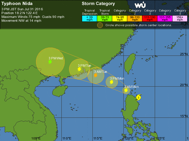
The Hong Kong Observatory (HKO), forecasts that now Tropical Storm NIDA will reach Typhoon status with winds as high as 130 kph when it hits the Pearl River Delta tomorrow night/early Tuesday morning.
Winds have already reached 75 mph with gusts of up to 90 mph this afternoon at about 960 km east-southeast of Hong Kong. NIDA was first classified as a Tropical Depression at 8pm on July 29th. It was upgraded to a Tropical Storm yesterday.
At 12 pm, The (HKO) issued the following statement:
“The Hong Kong Observatory will consider issuing the Standby Signal, Number 1 tonight. Based on its current forecast track, Nida will edge close to the coast of Guangdong gradually tomorrow and will continue to intensify. It will be rather close to the vicinity of the Pearl River Estuary on Tuesday, bringing heavy rain, squalls and rough seas to the region. Members of the public shall take all precautionary measures early.”
The HKO advises the following actions when the Standby Signal Number 1 is issued:
(Click here for a description of the various warnings)
“If you are planning an outing, remember that there is a tropical cyclone near Hong Kong which may affect your plans. Beware that strong winds may occur over offshore waters. Beware of possible swells. Listen to radio and TV broadcasts or browse the Observatory website on the progress of the tropical cyclone.”
If forecasts are correct, we may see a Gale or Storm Signal No. 8 or higher issued tomorrow. When that’s the case, the HKO advises the following actions:
“Complete all precautions now before gales commence. Lock all windows and doors. Fit bars into positions and insert reinforced shutters and gates if available. Adhesive tape fixed to large window panes in exposed positions will reduce damage by broken glass. Do not stand near windows on the exposed side of your home. Move all furniture and valuables away from these areas. Make sure you have a safe place to shelter, should windows be broken. Now is the time to decide which rooms you will use to shelter if the windows on the exposed side of your home become broken. Owners of neon signs should arrange for the electricity supply to their signs to be switched off. Park your car where it is least likely to be damaged. Avoid staying in the street. Return home as soon as possible if conditions so permit.”
We’ll continue to update this post with relevant information.